Tissington Dovedale Ilam Blore Thorpe Tissington Trail Tissington
20th May 2011
A magical dale with spectacular views
Who: PNO, PHW
Weather: Cloudy and windy. Cool on the higher ground. It threatened to but it didn’t rain all day. Eventually the sun appeared and out came the sun hat! A shorts day
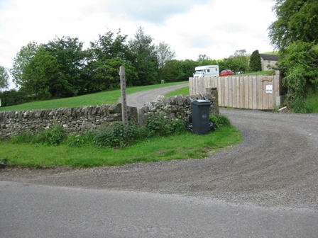
Parking: There is a car park at Tissington on the trail just through the village; it’s signposted and costs £3 per pay – cheap for Derbyshire. There are toilets there. PNO however found a cheaper alternative by parking in the village opposite Tissington Hall; there’s a polite notice asking you to park with you bonnet to the wall. The village has a nice café by the Hall that is open most days in the year.
The Walk
From Tissington Hall walk down the road to the T junction and turn right and walk along the main road and out of the village heading towards the A615. It’s the main route into Tissington so be careful of traffic. The road is called the Avenue and you can see why as it is tree line. On the road I was looking at the map when my glasses decided to fall to pieces. So I could barely make out the route in an area I was unfamiliar with and where there was a lot of detail in the route; it made for an interesting day.
In 750m you reach the entrance to the Hall grounds ie the gate house where you cross the A615. Go straight descending Washbrook Lane.
In 300m you cross Washbrook and immediately turn left over a stiled fence(FP).
This takes you into a field where you head diagonally left climbing to the top left hand side of a field. A stile (FP) by a five bar gate gives you access to a road.
Cross the road and then cross a stile (FP) by a gate entrance to a farm and caravan park. Head diagonally left and in 50m cross a stiled wall.
The path heads straight across a field before crossing another wall and an access track. On the far side of the track a stile gives you access to a field. Here head straight crossing this and then a second field.
At the far side of the second field cross a stile wall then head diagonally right through a field to a stile(FP Tissington) by a five bar gate. This gives you access to a lane.
Turn left down the lane and in 100m turn right (FP Thorpe) through a stiled wall. As you walk down the road to your left is Thorpe Cloud. On the far side the path follows the left hand side of a wall, with views opening up of distinctive features of Thorpe Cloud on your right.
At the bottom of the field you pass through a pedestrian gate and then a stiled wall. You now walk round the bottom side of Hamston Hill with the path now tracking down the bottom of a field hedged on your left to two gates which you go through. Continue to walk round the bottom of the field passing where a path joins form the left ( FP (Dovedale ¾ mile) and NT sign (Thorpe Pastures)) and tracking a wall/fence past the back of the hotel (full of expensive cars).
Ahead is the pointed (pyramid like) shape of Thorpe Cloud and between it and Thorpe Pasture (on the rhs) is Lin Dale which gives access to the start of Dovedale.
Leave the wall as it turns sharp left and cross a track in front of an old quarry heading for Lin Dale.
The path descends into the Dale to the rhs of a wall with Thorpe Cloud above you on the left. As the wall turns left down the dale follow it on its rhs, past a cave onto what becomes a good track to a 5 bar gate/kissing gate.
Through the gate is the river Dove and to the left a series of stepping stones across the river. This area is popular and a frequently photographed beauty spot. Today it was like Victoria bus station and from here to Ilam Rock there were plenty of couples out taking the air
Turn right, cross a wall through a stile (FP Milldale 2 ½ mile NT Dovedale). The hawthorn bushes on the hillside showed we were truly in spring. The path ahead is good, too good as it’s manmade.
The path tracks the river, which is heavily weired – presumably for trout fishing – until you climb away from the river at Lovers Leap before descending on a limestone path (which can be slippery when wet ). The path and valley bottom is tree lined and full of singing birds, red Campion and woodland flowers. Wonderful.
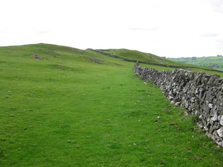
The geology of the limestone valley reflects the history of the place.
Ahead are the rock pillars of the Tissington Spires. It always amazes me what people will do. By the path are tree stumps with coins pushed into them.
But more of the geography of the valley appears in the form of a natural arch above on the rhs and Reynard’s Cave. The NT is trying to minimize erosion of people walking on the natural scree in the area by planting shrubs/trees to stabilise the ground. The path continues by the river, past caves, through a gate and past a memorial to R A Holmes and his son who ensured that the area became NT property.
Suddenly ahead is a footbridge, (FP Stanshope 1 1/4 m), with a beautiful backdrop of the limestone outcrop of Ilam Rock. Cross the footbridge and on the far side turn right (NT Ilam Rock; Ilam 2miles). The OS map shows the path going straight up from the bridge but a good path walks up the river bank for 100m or so before turning left ( FP Ilam 13/4mSteep ascent) and climbing straight up the side of the valley.
It’s a steep ascent and one to get your heart going. It ascends up a partly stepped route through Dovedale Wood until suddenly the gradient eases and the views open up across the valley.
The path then heads south following the left hand side of a wall along the top of wood to a gate in a wall (NT Dovedale Wood; FP Ilam). The view through the gate is worth the effort and is one of the best in the southern white peak. For straight ahead is Thorpe Cloud in all its magnificence.
You may want to venture up to the track above you on the right, but no the way ahead is straight across a grassy slope at the far side of which is a FP (Ilam) indicating the start of a clear path.
The path is clear and well waymarked and takes you to just below Air Cottage where the path turns right and heads up past a waymarker post to a pedestrian gate by a 5 bar gate.
Go through the gate and climb to a further gate 20m ahead. This gives you access to a track.
Turn left and walk west away from Air Cottage towards Ilamtops Farm.
At the 5 bar gate allowing entrance to the farm turn left (waymarker) and walk along a tree line track with a wall on your right. Soon the track is walled on both sides. At the end of the track a gate gives you access to a field. Carry straight on following the left hand side of a wall to the top right hand corner of the field where a gate gives you access to the northern end of Bunster Hill (NT Bunster Hill).
Turn right through the gate and descend following the left hand side of a wall. As you drop down views of Dovedale open up with Ilam in the trees. Follow the wall down until a path crosses the wall on your right. Then head diagonally left to a stile in the wall straight ahead and at the bottom of the valley which is to the left of the first tree.
From here head diagonally left through a couple of fields to a ladder stile by a five bar gate.
Cross the stile. On your right is a tree lined pond. Carry on straight along a path which takes you to a track (PNFS Dovedale).
At the track go straight and drop down to a gate (NT Bunster Hill) which gives you access to a road from Thorpe to Ilam.
Turn right and walk up the road and into the village. PNO said there is always an ice cream van at Ilam and there was; but first we stopped by the bridge and had lunch on a bench by the river. It was peaceful and quiet for such a popular spot.
As you approach the village ahead is a memorial – it was under wraps for repair . Bear right along Lodge Lane on the road to Rushley and walk through the village past the entrance to the park. As the road begins to climb there is a school on the right (PHW thought it was a church).
Opposite the school turn left along a track with the boundary wall to the park on your left.
We walked along the track until it began to bend left round the back of the House and Car park, where we turned right off the track and headed for a post on the far side of grassland.
When we got to the post, head right and drop down on a track which takes you to a footbridge over the River Manifold.
Cross the bridge. On the far side of the bridge PHW took to the bushes – he said that the ice cream had loosened his bowels. But wait we said as there are people coming towards us. Can’t came the reply. So he scuttled off 20m to the right of the path and tried to hide behind some skinny bushes. He couldn’t hide the fleshy buttocks.
PNO and I carried on straight to a stile in a wall. This marked the start of a steep climb up the side of the valley. Through the stile climb up a grassy bank to a gate in a wall. As we to close to the wall we turned and saw PHW scuttle back across the bridge. Frantically we got his attention and he followed us up the path.
Through the gate. the path continues to climb straight up ( there is a waymarker on a tree). Again we had to redirect PHW onto the path. Goodness knows how he manages to navigate when he and his good lady go out walking;he must do a lot of excess miles. As you gain height there are wonderful views to your left of Bunster Hill and Thorpe Cloud – worth the effort. Eventually the gradient eases and ahead is a wall.
Head for the top left hand corner where you cross a wall via ladder gate by a 5 bar gate. The path then climbs along the left hand side of a wall.
As the gradient eases the track leaves the wall and heads towards a clump of trees on the next hill – Hazelton Clump. The track then bends right contouring before reaching a good track which drops down to a gated wall. Through the gate a good track climbs round the Hazelton Clump – the hill with the trees on the top.
After 1km you reach a minor road which you access via a five bar gate. Turn left and walk down the road for 200m before turning right through a gate and bearing right to a wall which drops down into the bottom of a dry valley using a good track.
At the bottom of the valley turn left and walk towards Blore. After crossing stiled wall by a five bar gate the path moves left off the bottom of the valley by a coppice on the right. The path climbs to the top of a bank then heads parallel to the bottom of the valley until you reach the top left hand corner of a field.
Here a stile by a derelict five bar gate. gives you access to what looks like someone's garden.
Head diagonally left by the side of the garden to a further stile by a five bar gate. This gives you access to a church graveyard.
Walk on the right hand side of the church and then head diagonally left on a path that takes you to the road through Blore (FP).
At the road turn right and walk out of the village.
The lane is narrow with high hedges and looks like a west country road. It was a good job a car didn’t come past as I doubt we would have survived.
200m after leaving the last house the road bends right then takes a sharp left. Here turn left over a stiled fence.
Follow the path down the left hand side of a wall. At the end of the first field, turn left through a gate opening and climb up a track that heads diagonally right away from the wall.
Soon the gradient eases and carry on straight heading for a distinctive Brown sign for Coldwell Farm in the distance by a wall. A stile by a five bar gate gives you access to a road (FP).
Cross the road and go down the access road to the farm (FP). The track leads down into the farm. Keep to the left of the farm building where you can see a clear track. We were met by the friendliest sheep dog I’ve ever come across who insisted we through his stick for him to chase – it was actually a piece of turnip! The walled track leads you away from the farm to a five bar gate.
Through the gate the tack descends to the bottom of Dovedale which you cross via Coldwell Bridge. PNO found a pair of well worn glasses and for the first time in the day I could read the map.
The track climbs away from the river through a five bar gate and past a milestone to Cheadle – 11 miles. Clearly we were on an old packhorse track.
The track climbs steadily for 0.5km until near the top and just before you reach Thorpe turn left (FP).
Head diagonally left to a stile at the top a short walled section. This gives you access to a track which drops down to a road (FP) on the outskirts of Thorpe.
Turn left and walk down the road for 20m before turning right down a track (FP). The map makes you believe that you will walk down a track, but don’t be deceived.
The track descends and soon leaves the houses where it becomes a path which winds its way through wild garlic and trees before crossing steam to a minor road (FP).
Turn right and walk up the minor road - like Cornwall again – for 0.6km to a T junction.
Cross the road ahead and through a gated fence take a path that heads straight across a field to a second gated fence.
From here the path drops down to a gate in a fence which gives you access to the Tissington Trail.
From here the going is easy and fast – unless you have cramp. It’s about 2 km to Tissington.You pass Thorpe, Fanney Bentley Cutting, go under a lovely stone bridge and cross the A515.
As you approach Tissington just before you cross a small bridge turn left of the track and drop down and cross a gated fence.
The path heads diagonally right to the top right hand corner of the field where you pass through a pedestrian gate and continue diagonally right along the side of a stone wall.
At the far side of this a turn right through a stile and drop down through a field to the bottom right hand corner where a gate gives you access to The Avenue just as you enter Tissington by the Candle Shop – built in 1861.Turn right and then first left and walk up the road to the car.
Summary
A good walk on paths and tracks but with a lot of detail for the navigator. There are excellent views of Bunster hill and Thorpe Cloud. Dovedale is always magical except for the people. There are some pretty villages – Ilam in particular – and a number of pleasant places to stop rest and slumber.
Home Start Point Peak District Books Related Sites Text Only Map&Summary Diary
Home Start Point Peak District Books Related Sites Text Only Map&Summary Diary